 |
Ice reconnaissance and navigation. |
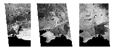
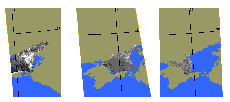
The radar images of the Azov Sea were acquired by the SICH-1 radar from left to right (18.02.96, 24.02.96 and 01.04.96 respectively), which demonstrate the changes in the thematic data obtained after processing of these images. The radar data enable the inland sea ice status to be operationally monitored and the safe navigation to be provided in the most efficient manner.
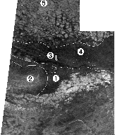
 The combined (based on three images) radar image
of Alaska region was acquired by the SICH-1 radar. Various shapes of
the Arctic ice are clearly discernible from this image:
- 1 - medium and thick fast ice;
- 2 - hummocked one-year fast ice;
- 3 - polynya back of the fast ice;
- 4 - one-year medium and thick ice;
- 5 - multi-year ice.
The utilization of the SICH-1 radar data permits the real-time monitoring of the ice status in the Arctic region, the safe and cost-effective passenger and cargo transporting by sea.
© CRSE, April 1998

