 |
Atmospheric phenomena monitoring |
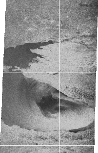
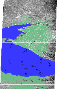
The radar image (left) of the Eastern part of Ukraine, Northern Caucasus and the Black Sea was acquired by the SICH-1 side looking radar (27.10.96 1:21 - 1:27 UTC) and thematic map. The images show the processes resulting from the high-power cyclone: - the sea surface wind field and the heavy precipitation in the regions of Kuban and Northern Caucasus. The processed data (right image) suggested that this cyclone is rather powerful: the sea surface wind velocity near the coast of Turkey is as high as 22 m/s. The most hazardous for navigation is the atmospheric front zone where the changes in the direction and speed of the wind at a distance of 1 to 2 km range from 5 to 22 m/s. Although the non-tropical cyclones are less powerful than the tropical ones, they may be highly damaging. For instance, the cyclone that suddenly hit Ukraine on November 15, 1992 caused damage estimated at more than 50 million US dollars. The use of real-time radar data makes it possible to adequately respond to situations, to give timely warnings and to reduce damage.
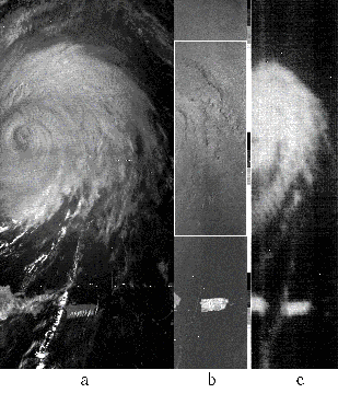
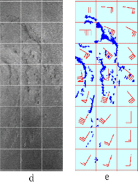
The optical (a), radar (b) and microwave radiometric (c) images of the hurricane "Louis" acquired by the SICH-1 satellite on September 10, 1995. At the right there is an enlarged portion of the radar image (d) and the sea surface wind map processed from the radar data (e); it shows sea surface wind direction and wind velocity. In terms of the preliminary data the hurricane "Louis" was placed into the category of the most hazardous (the extent of its cloud masses ranged up to 2000 km). The Carribbean Sea countries have undertaken a great many preparatory and safety measures which were worth tens of millions of dollars. It was precisely the SICH-1 data that proved to be useful in establishing that this hurricane was not very powerful; its maximum sea surface wind velocity was no more than 35 m/s. To put it differently, this tropical cyclone should be basically classified as the most powerful tropical storm. Using the real-time radar data makes it possible to evaluate the active atmospheric processes that pose a real threat and to appropriately meet whatever situations.
© CRSE, April 1998
